Friday, July 30, 2010

15th July, Mount Rainier, Mowich Face

The Mowich face of Mt Rainier, with our line in red. Dubbed 'the most striking and beautiful line I've seen or skied in the continental US' by first descensionist Andrew McLean.

Booth and Colin Haley and myself skied the Edmunds Headwall on the Mowich face on July 15th. Since I moved to Seattle a couple winters ago and slowly became acquainted with the surrounding mountains, the Mowich face quickly burrowed itself into my conscience, its hanging glaciers, steepness and shear magnitude reminding me of certain parts of Les Alpes. The Edmunds Headwalls was first skied by none other than Andrew McLean and Carl Skoog, together with Doug Ingersol and Armand DuBuque in July 1997. As last spring unfolded, and suspicions grew that the high slopes of Rainiero were in decent nick, I wanted to make the most of a small window in between family visits and summer relocation. Seemed like the 14th - Bastille day- would be a possible descent date- a fitting homage to the nation that pioneered steep skiing and that is suffering from so much malaise sportive this summer hehe… In the end, we had to make do with Bastille plus un.

We left the Mowich lake trailhead on Wednesday 14th, late in the morning. The Haley bros don't deal in unnecessary crap, so they hid my DSLR as we were getting ready. And they were quite convincing too:

As soon as I saw the face, I was very excited- in the previous days I'd been reading Ryan Lurie's report of the route from just over a year earlier, and the top section of the face looked a lot whiter this year.

Onwards and upwards...

After a few hours hiking through beautiful alpine meadows we made it onto Ptarmigan ridge, and found a very nice little wind shelter around 8.5k. We enjoyed a lovely evening eating caviar, drinking champagne and discussing the various forms of showing one's full love to scrumpets. In this arena, Colin is surprisingly non-extreme.

Booth meditating at camp


The sun setting on Mother Mowich

We left the next morning around 5, and promptly made it to the Mowich glacier - the choss downclimb was minimal and we could ski most of the way down from the ridge. We traversed the glacier slowly gaining height until we were below the Edmunds Headwall. The rimaye crossing was uneventful (climbers left), and the climb thereafter progressed smoothly.

Colin on the way up

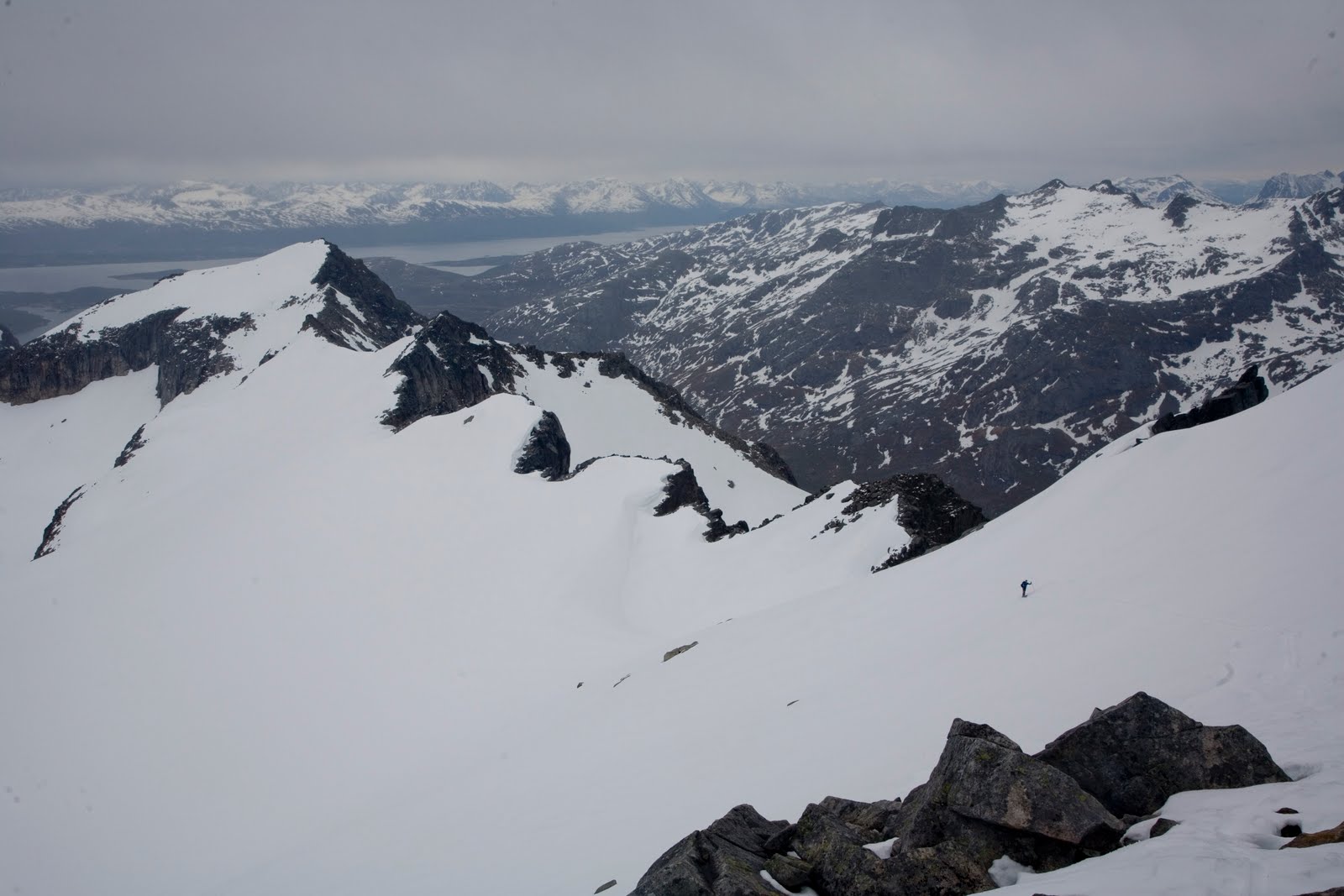
Myself, Eric Wehrly and Colin traversing above the upper schrund


As we were traversing above the upper schrund, in a cool and surreal moment, two local badboyz of skiing almost simultaneously appeared from the sunset ridge, Dan Helmstadter and Eric Wehrly- very cool to meet them! The five of us went on to Cap Liberté where it was bloody windy. We then skied some blower rainier summit pow pow to a cool wind shelter above the Mowich Face where we hanged out and waited for the Sun to shower Mowich in corn radiation. At 3.30pm we set out. We skied the upper face together, in beautiful snow conditions over immense exposure- truly memorable turns.

Steep skiing on the upper section of the Mowich


Dan and Eric then went their way towards Sunset ridge, while we headed down the Edmunds. The top schrund where it's a touch steeper and firmer was definitely focus time. The rest of the descent, where it mellows out considerably, was corn-fast-ish-turn paradise. We got lucky and timed it just right- soft enough at the top, not too soft at the bottom.

Booth in the middle section of the face


...Just Lovely...


The Mowich glacier ski was fun too, but getting a bit sticky towards Ptarmigan ridge. The climb back up the ridge wasn't much fun, but it could have been much worse… Got to camp, packed up, packed out, got packed by a cop in Wilkeston, and missed the Autobahn.

A perfect day :)

Wednesday, June 30, 2010

14th June, Mt Maude North Face

Aaaaaaaaaah Maude... you beautiful thing, how are you?

I'd been wanting to ski Mt Maude's north face for some time. It's a bit of a classic here among alpinists in the PNW, and it is quickly gaining that status among skiers too since it was first skied by the late Ben Manfredi in July 2002.


North Face of Mt Maude, with our ski descent. Photo taken on 18 June 2010 by Scot McAlister


I'd driven up with Aaron, James and Andy ealier in May, only to find the road gated still 13 miles or so from the trailhead - which eventually led us to Colchuck. This time, I went up with Booth Haley and with bikes in case we couldn't drive to the Phelps Creek TH. As (very bad) luck would have it, we hadn't driven a mile up the dusty road when we came across a massive fallen log blocking our way. Shit. After trying unsuccessfully to push it with my Subi, and thinking that burning it might not be a good idea, we decided to camp and bike in the next morning. I never thought a chainsaw would be a candidate for my quiver... Got up at 4am, and after a quick breakfast we where on our way, on our very convenient road bikes. The Phelps creek trail was in pretty good condition, though there were a couple of pretty full streams running through it, one we had to cross barefoot. Eventually, we decided to make a right turn, and went up lookers right of Leroy creek.

Came out of the trees just under the SW face of Maude, which was pretty beaten up, with runnelled gullies and wet slide debris everywhere.

Booth with the South West face of Maude behind

We climbed up the SW shoulder onto eventually the gentle south slopes that lead to the summit- we saw 2 ski tracks and a bootpack on our ascent route. Had a lovely little lunch on the summit, with clear views all around us. Glacier Peak looked stunning.

Glacier Peak poking through the clouds


It was below freezing at the summit but I was hoping the strong June sun had worked its magic on the north face- Booth is a badass and was in leather boots and 130cm skis, so we were hoping for a little cream.

Booth with his homemade whippet and 130cm skis...

Summit!

The face turned out to be just like Aaron's (who sadly was otherwise committed at sea level): beautifully chiseled, a paragon of beauty and a birthplace of intense emotions. Ok joking aside, it was f***** rad. Steep, exposed, super super fun. Quelle ambiance! Booth was kind enough to offer to take some pictures, a nice change since I'm usually on the other side of the lens

Dropping in...


... to some superb skiing...


We skied skier's right on the main gully, where the snow was a bit softer. Lower down, the snow had slabbed off the main gully. I went skier's right where it was narrow but passable, Booth went left.

...in a terrific environment

will it go?

Achtung Bergschrund!!

We re-united on the glacier and started traversing east, towards the Ice lakes. We eventually traversed all the way back to the south side of Maude, and skied back down into Phelps creek down the basin immediately south of Leroy creek. After a somewhat miserable bike ride under bruising skies, we made it back to the car and Fraulein StPauli around 10pm, tired but utterly joyed after an amazing day in the mountains. Thanks Maude!

1-8th June, Tromso, Northern Norway

Last summer I was a very lucky boy. I had the fortune that one of the most important conferences in my field (yes, that's work!) was held this past June in the far north of Norway, in a cool little city called Tromso. Tromsonites (or could it be Tromsoners?) like to describe it as the northernmost city in the world, host of the northernmost university, hospital, and brewery. The conference ran for 5 days, and I had a couple spare days at the end. The midnight sun visits the region from the end of May to the end of July, which means that one can ski all the time. And the terrain is fantastic. Heaven on Earth? or just a case of Norwegians being a little bit more blessed than the rest of us sinners?

I was joined by my beautiful friend Simon Weatherall who came up from his summer retreat in southern Norway- Chamonix extreme skier, extreme modeler, extreme taxi driver, and extreme scrumpeteer. It certainly bode very well. The weather didn't fully co-operate but we still enjoyed the odd weather window that allowed us to explore the region's delights. Snow levels were around 300-400 meters asl, which meant a little hiking to get to the goods, but nothing too serious... AND we even scored some powder.


Tromso, with Whale Island in the background


The man


The midnight sun

On June 1st we ran over to the mainland after Simon picked me up from the conference, excited to see the sun poking through the clouds for the first time in days. It had been raining and cold in town, and we could see there was quite a bit of fresh snow up on the hills.


Up Knutsenkogen


Norwegian Coolies...


and Norwegian Peaks...

We essentially wandered up a valley and started climbing an east facing couloir that looked fun. The views around us were beautiful, shining in the midnight sun. It was a strange sensation to see north facing slopes sunny and south facing slopes shady. Towards the top half of the coulie, we actually found nice boot-top powpow. June in Norway? Love it!

Simon at the top of the couloir (to his right)


The top pitch


Lower down. Steep and Tight!

The next day, 2nd of June, our plan was unchanged. Simon picked me up after the conference and we drove over to Kvaloya, 'Whale Island' in Norsk, to ski a fun north facing line at the head of a fjord that had a tongue of snow going down almost to sea level. In spite of leaving the car in warm sunshine, the next band of shite-ness was quick to dampen our hopes of sunskiing and so the summit greeted us with rain. The ski was a little wet, but that isn't always a bad thing, aiiii?


The route goes up the finger of snow on the left

Norwegian fjords...


Simon skinning up the glacier, with the mainland in the background


The line: up the left, behind the central buttress, up to the snowy summit on the right

After the conference ended on the 4th June, we left Tromso en route to the mystical land of Lyngen. Much has been written about this place. Even more spectacular than the land around Tromso, it is truly a paradise for skiers. Alas, when we arrived there, we found a higher snowline than in Tromso (probably around the 500-600mt mark) and even worse weather, the summits shrouded in thick fog. We spent a night in some godforsaken hostel in the hope that the following morning would dawn somewhat more promising. Far from it. It was crappier than crap. So we decided to drive to the Malaren Peninsula, which is just southwest from Tromso. I'd seen some promising peaks and quite a generous snow cover during my time in the city.

We didn't have much info on this area though, so we were guessing where it would be best to go. Again, the lack of easy approaches, with no high roads, or even seemingly trails (at least we did not find them) conditioned us. Nevertheless, we camped on a field by the road in a valley that seemed somewhat promising. That evening, we bushwacked a couple miles up the valley, slow and wet progress up thawing mud. For good laughs, it included an incredibly cold river crossing.


Suffering

Simon and our destination, the peak center-right

'That line doesn't look too shabby!'

From the summit, looking west

And East, with Tromso the island on the left

The line we skied had a nasty entrance, most of the ridge was massively corniced but we found a way in. I decided to stay on skis, but got my axe out and gingerly sidestepped the steep, icy wall of death. I didn't have a helmet on, and a fall would probably have been a bad idea. Simon downclimbed. The top half of the ski was fun, with an inch or two of fresh on top of a smooth, firm base.


Simon scoping out the entrance...

...and the entrance scoping out Simon


Fun ski!

Skiing at midnight with incredible views. We'd camped at the head of the valley not far from the water


And a nice bushwack back to camp

Over the next two days, we again ran into piss poor weather and had 'fun' skiing some mellow wet snow in the fog in the hills above Tromso. And so with a wonderful last supper shared with our beautiful hosts Tori and company we ended a marvelous trip. Would love to go back, especially earlier in the season. Takk Norge!!!

Friday, May 21, 2010

13-16 May, Mt Olympus, WA

I went up to Mt Olympus, the highest (and most glaciated) peak in the Olympic mountains, last weekend to help my friends TJ and Aaron with some glacier survey field work. TJ runs the University of Washington glacier surveys on Blue Glacier and the other glaciers coming off Olympus. Having not done glacier fieldwork in years (and missing it...) I had no problem in accepting the invite to head out there... even if it did involve 22 miles (34km) walking through rain forest and just under 2000mt (6000') climb.

The plan was to spend a couple nights up at the Snowdome research station aka hut, at about 6,500 feet and a mere two miles from the West summit of Olympus. We got what looked to be a 6 day weather window starting last Tuesday (11th May), but had to delay because we couldn't locate the hut key from the National Park service till Thursday. Key in hand, we loaded up packs Thursday afternoon and headed up the Hoh. Leaving the visitor center at 500 feet above sea level, it looked like this:

Aaron not looking too excited about carrying these babies...


Our heavy packs with skis, glacier gear, etc. got some funny looks. Quite a few punters about wondering where the hell we where going. There's a few short loop trails (like a mile max) where most of the tourists mill around, and beyond these the Hoh valley trail runs along the north banks of the Hoh, pretty damn flat for the first 12 miles.


In the rainforest... a long way away from snow


The first afternoon we walked this flat section and camped at a beautiful spot by the river, just before the trail starts to climb up.


Our camp spot on the first night


The next day was on the tough side. About 12 miles, lots of vertical straight from the word go, and no chairlifts in sight...
We finally made it to snow probably around mile 16 (after 25km...), and reached the bottom of the Blue glacier at mile 18.


About to reach Blue glacier, Panic peak and the Snowdome in the background

Skinning up the lower glacier was amazing. The solitude was incredible, and coupled with the sights around us it gave us the feeling of being more in a place like Alaska. Mount Mathias and the ridge that runs west first appeared, with beautiful steep snow covered faces that dropped onto the Blue glacier. TJ unpacked his nerd stick, turned on the GPS unit, and proclaimed himself hard at work.


We quickly rounded the lower portion, the icefall and summits of Olympus now in sight, and came off the glacier to start the moderately steep climb up to the Snowdome.


Mount Mathias on the left, the Blue glacier ice fall on the right


The Blue glacier ice fall and the various Mt Olympus summits


Our guessing game of where we were turned to relief when we saw the hut, or a small piece of the hut. Only the roof was poking through the snow, which at this time of the season was probably close to its seasonal maximum, leading to questions of 'which side is the door on???'


Had there been another couple feet of snow, we would have been wandering in the white desert... an unwelcome prospect after a 11 hour day under full packs. As it was, we had to locate the door (3rd try) and spent a good two hours digging and unjamming the door.


Luckily trusty DHo is a sneaky little bugger and he managed to slip in the door (which was jammed from snow and ice that had blown in) and after some tugging and forcing we were through and surveying our lair for the following nights.


We spent the rest of the evening sitting on the roof which had warmed nicely under the suns rays looking in awe at the incredible scenery around us, probably 20 miles and a days travel from the nearest human...


Unfortunately on the way up my left knee had become quite sore, so the next day I stayed at the hut reading and chillaxing (i found some goodies in Gui's backpack hehe) and icing the knee while Aaron and TJ went out on the glacier taking GPS surveys. I gave Aaron my camera and he did good!


TJ on the Cirque portion of Blue glacier


The boys got back in the late afternoon, and we spent the rest of the day lounging on the hut's roof and enjoying another of TJ's wonderful dinners. After dinner, we climbed up to Panic peak, which is a 5 minute walk out of the hut, with some amazing views in all directions. Unlike the previous day, there were some high clouds rolling in, harbingers of nastier weather to come, but for now just providing one of the most amazing sunsets I've ever seen in the mountains. The alpenglow was spectacular at one point.


Looking west


Cool Alpenglow...

The following morning we packed up and skied down the Blue glacier en route back to civilization. The snow was super firm and smooth, really fun to ski, even with our heavy packs. The lower glacier was a fast straightline down to the morraine, and the surface was covered by millions of ice worms- I've never seen anything like it!

And after the fun ski, came mile after mile of trail walking, aided by painkillers and gravity and thwarted by, well, just a shit ton of miles of trail.

We were pretty happy to make it back to the parking lot, but even happier with the whole experience. I would love to return to that area with a more ski-minded agenda... Lots of cool lines... and probably lots of first descents lurking...